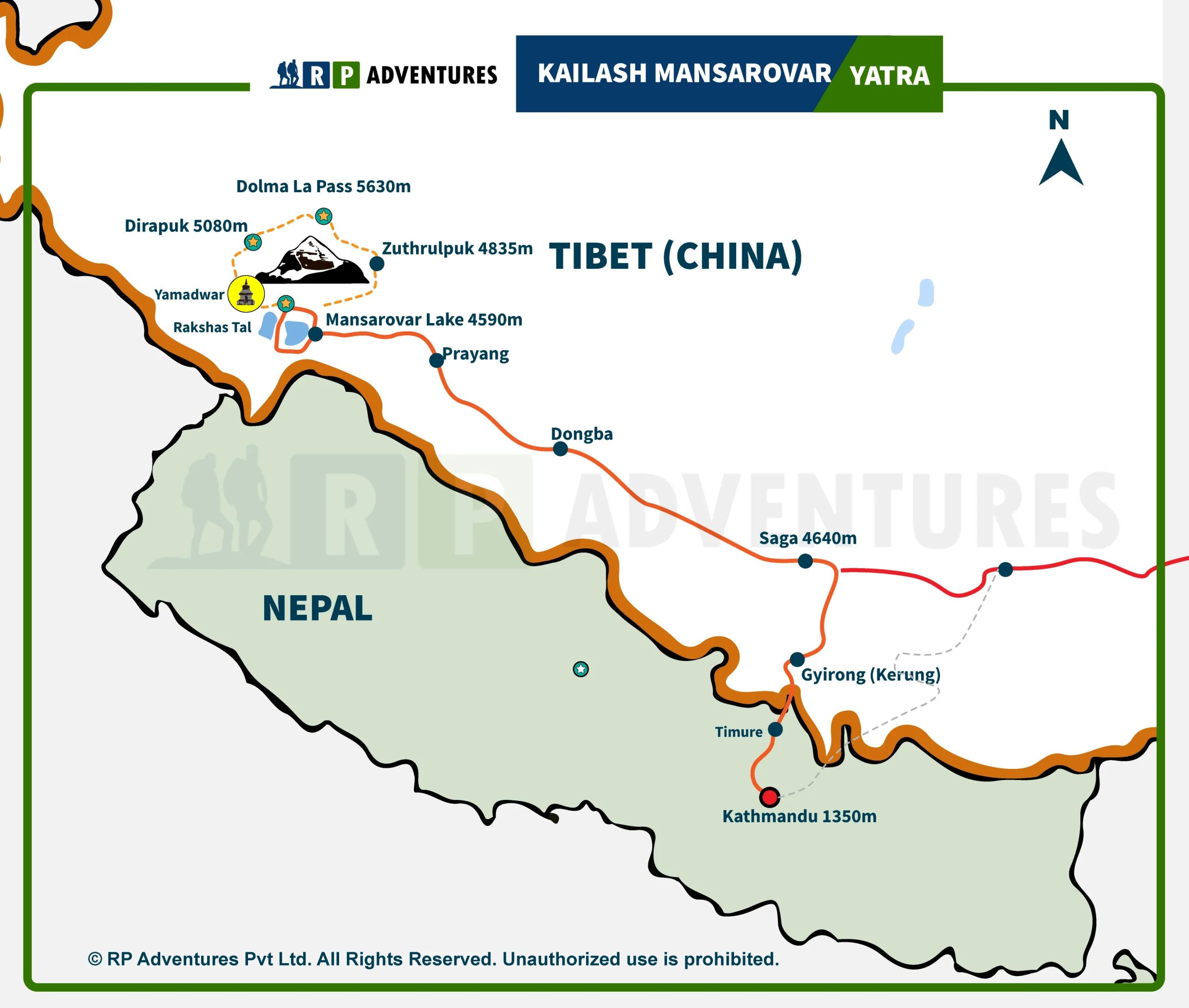
Planning a trip to Mount Kailash is not like planning a normal holiday. The roads are rough, the air is thin, and the weather can change within an hour. This is why a good Kailash Mansarovar Yatra maps matters so much. Kailash Mansarovar Yatra maps helps you understand where you are going, how far each stage is, and how much your body needs to adjust at each point.
At RP Adventures, we have guided pilgrims and trekkers on this route for years. We know the roads, the rest stops, and the small details that most travel guides skip. In this article, we walk you through the Kailash Yatra route map, the Outer Kora, the Inner Kora, and the path from Lake Mansarovar to Mount Kailash. We also share why a proper map is one of the most useful tools you can carry on this trip.
Kailash Mansarovar Yatra Route Map
There are three common ways to reach Mount Kailash, and each one suits a different type of traveler.
Overland Route from Kathmandu
This is the classic route and the one most pilgrims choose. From Kathmandu, you drive to the Nepal-Tibet border at Kerung (Rasuwagadhi), then continue toward Saga, Lake Mansarovar, and finally Darchen, the base camp for the Kailash Kora. The full overland trip usually takes around 14 to 18 days, depending on your itinerary and rest days for altitude. Major stops along the way include Kerung, Saga, and Lake Mansarovar before reaching Darchen.
Helicopter Route via Nepal
For travelers who want to save time or who are worried about long road travel at high altitude, a helicopter tour from Kathmandu is a good option. You fly to Simikot or Hilsa, cross into Tibet, and then drive the rest of the way to Darchen. This route cuts the travel time by several days, though it costs more than the overland trip.
Route from Lhasa
Some travelers enter Tibet through Lhasa instead of Nepal. From Lhasa, the drive to Kailash passes through Shigatse, Lhatse, and Saga before reaching Darchen. This route gives you extra time to see Tibetan monasteries and towns, but it also means more days of driving at altitude, so proper acclimatization is important.
Whichever route you choose, RP Adventures builds the itinerary with enough rest days so your body can adjust before the actual Kora begins.
Mount Kailash Outer Kora Route Map
The Outer Kora, also called the Kailash Parikrama, is the main pilgrimage walk around Mount Kailash. It covers about 52 kilometers in total, and most pilgrims complete it in three days. Around 10 kilometers of this distance, from Darchen to Tarboche, is usually covered by vehicle, which saves your energy for the harder walking sections ahead.
Tarboche to Dirapuk
This is the first trekking day. It covers roughly 12 kilometers and is fairly gentle compared to what comes next. You walk along the Lha Chu valley with Mount Kailash visible on your right for most of the way. Dirapuk sits at around 4,900 meters and gives one of the closest views of the North Face of Kailash.
Dirapuk to Zuthulpuk
This is the toughest day of the Kora. You climb over the Dolma La Pass, which sits at about 5,630 meters, before descending to Zuthulpuk. The distance is around 18 to 22 kilometers, and the altitude gain and loss make this a long, tiring day. Most pilgrims start very early in the morning to finish before dark.
Zuthulpuk to Darchen (via Chongdo)
The final stretch is the easiest. It covers about 10 to 14 kilometers, mostly downhill or flat, ending back at Darchen or Chongdo. By this point, most pilgrims feel a mix of tiredness and relief, since the hardest part of the walk is already behind them.
Mount Kailash Inner Kora Route Map
The Inner Kora is a shorter but far more demanding route than the Outer Kora. Local tradition says it should only be attempted after completing the Outer Kora at least once, and even then, it is meant for experienced trekkers who are used to high altitude. Permission from local authorities is also needed, and this can depend on weather conditions and the season.
Key points along the Inner Kora include:
- Charan Sparsh – a spot where pilgrims touch a rock believed to hold the footprint of Lord Shiva.
- Kuber Kund – a small holy lake linked to Kuber, the god of wealth in Hindu belief.
- Nandi Kora – a shorter walk around the peak believed to represent Nandi, the bull associated with Shiva.
- Ashtapad – a sacred site connected to Jain tradition and considered a place of liberation.
- Atma Linga – a natural rock formation seen as a symbol of the soul.
- Saptarishi Caves – caves linked to the seven sages of Hindu mythology, tucked into the base of the mountain.
Because the Inner Kora sits at a higher and more exposed altitude than the Outer Kora, weather can shut down access without much warning. Snow, wind, and low visibility are common, so this part of the trip should never be planned without a guide who knows the current ground conditions.
Lake Mansarovar to Mount Kailash Map
Lake Mansarovar is one of the highest freshwater lakes in the world, sitting at around 4,590 meters. Most pilgrims stop here to bathe and pray before continuing to Darchen. The drive from Mansarovar to Darchen takes a few hours and passes through open Tibetan plains with clear views of Kailash on a good day.
Along this stretch, many travelers also visit Rakshastal, a lake near Mansarovar with its own local legends, and Chiu Gompa, a small monastery built into a rock hill right beside the lake. These stops are not compulsory, but they add depth to the trip and give you a few good photo points before the trekking days begin.
Why Use a Kailash Mansarovar Map?
A route map is not just for decoration in a travel brochure. It is a practical tool, and here is why it helps:
- Better planning – You can see the whole route before you go and plan your days around it.
- Understanding distances – Knowing that Dirapuk to Zuthulpuk is the longest day helps you prepare mentally and physically.
- Elevation awareness – The map shows where altitude increases sharply, so you know where to slow down.
- Trekking day preparation – You can pack the right gear for each stage instead of carrying everything for the whole trip at once.
- Locating overnight stops – Knowing where you will sleep each night reduces stress during the trek.
- Improved safety – In case of an emergency, knowing the route helps you or your guide make faster decisions.
Get the Latest Kailash Mansarovar Route Map from RP Adventures
Routes and permits for the Kailash Mansarovar Yatra can change from year to year, and sometimes from season to season. Border rules, road conditions, and permit requirements are updated by local authorities, and an old map may not reflect the current situation.
RP Adventures keeps track of these changes and shares updated maps, route details, and itinerary advice with every group we take. If you are planning a Kailash Mansarovar Yatra from Kathmandu, a Kailash helicopter tour, or a Kailash overland tour through Tibet, reach out to us. We can walk you through the current route, help you choose between the Outer Kora and Inner Kora, and build a schedule that suits your fitness level and travel dates.
Frequently Asked Questions
How long is the Mount Kailash Outer Kora?
The Outer Kora is about 52 kilometers. Around 10 kilometers from Darchen to Tarboche is done by vehicle, and the rest is covered on foot over three days.
Can beginners do the Kailash Parikrama?
Yes, the Outer Kora is done by pilgrims of many fitness levels, though the Dolma La Pass day is physically demanding. Good preparation and a slow pace help a lot.
Is the Inner Kora open to everyone?
No. The Inner Kora is meant for those who have already completed the Outer Kora and are experienced with high-altitude trekking. Local permission is also required, and weather can limit access.
Which route is faster, overland or helicopter?
The helicopter route via Simikot or Hilsa is much faster than the overland route from Kathmandu, though it costs more.
How many days does the full Kailash Mansarovar Yatra take from Kathmandu?
The overland trip usually takes 14 to 18 days including rest days for altitude. The helicopter route can be shorter, often around 8 to 10 days.
What is the best time to visit Mount Kailash?
The travel season generally runs from May to September, with June to August being the most common months due to better road and weather conditions.
Do I need a guide to follow the Kailash Yatra route map?
Yes, a local guide is required for the Tibet portion of the trip, and having an experienced team like RP Adventures makes route planning, permits, and daily logistics much smoother.